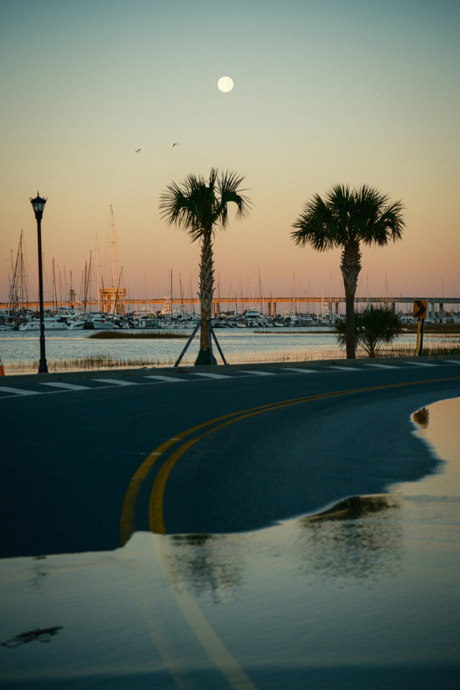
It’s snowing in Charleston, South Carolina, for the first time in seven years as I call Jared Bramblett to talk about his project, Mean High Water, which documents the impacts of sea level rise and flooding in the Lowcountry. Bramblett, a water resources engineer and self-taught photographer, has been artfully and statistically documenting the effects of rising waters in Charleston through this project since 2020. He’s working towards creating a public exhibition, but for now, his website serves as a permanent viewing space for his poetic imagery and rich scientific information behind flooding trends.
I ask how his snow days have been, noting, for lack of a better word, how it’s a “funny” backdrop for our discussion about his art-as-activism approach towards Charleston’s climate-related water problems. Bramblett’s been an avid street photographer since he first picked up a camera around 2010, with his photographic works revealing a keen interest in how humans interact with living, changing environments. “A lot of the things I’m driven to photograph are the mundane or the banal,” Bramblett says. “With Mean High Water, I’m looking for surreal moments or scenes that capture the beauty of Charleston, the essence of Charleston, and the stark impact of what water in these areas looks like.”
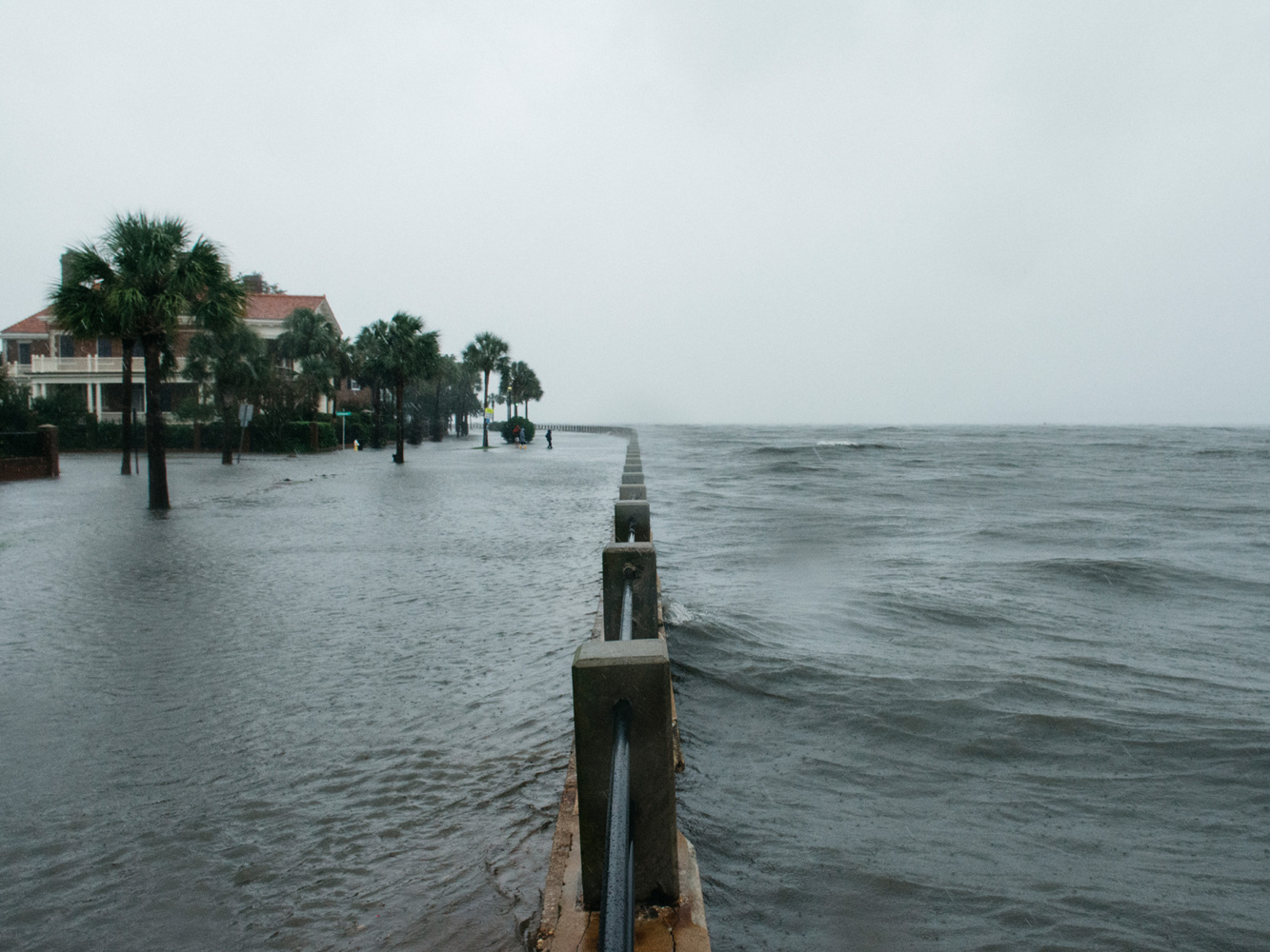
He makes a photographic record as floodwaters surround the Holy City’s iconic churches or, in his most-shared image, as Hurricane Irma surges overtop the Low Battery seawall, stretching along the downtown peninsula’s lower shores.
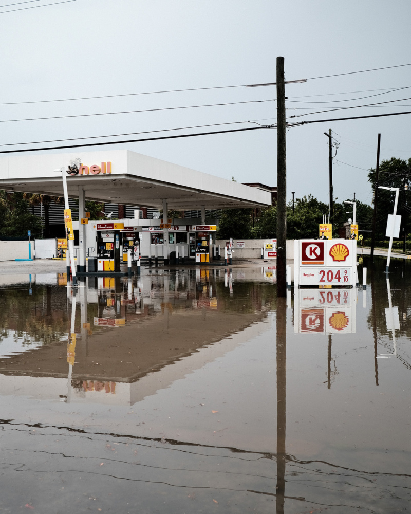
Bramblett catches a horse-drawn carriage full of tourists navigating through tidal flooding on East Bay Street, one of the most recognizable spots in the city and home to the famous “Rainbow Row.” Another photo shows a downtown Shell gas station flooded beyond use, thanks to tidal surges–flooding can happen here even with little or no rainfall–and you’ll notice why it’s been nicknamed the ‘hell’ gas station after the ‘S’ on the sign burnt out. One commenter put simply what Bramblett captures: “Beautiful photos. Horrific reality,” under his series of the Charleston City Market during the 4th highest nor’easter tide on record.
Beyond his photo-taking, Bramblett works as a water resources engineer. He’s part of the team that delivered the recent Charleston Water Plan1, unveiled by the City of Charleston in fall 2024. It’s the first city-wide flood risk management plan that examines what should be done to control water flow over the next 25 years.
“The lived experience I have as a photographer out in the water has influenced my career as an engineer so much,” he says, sharing how he goes out on bike to make his stunning photos of Charleston flood waters. He wears waders and takes lots of care in the dangerous and dirty water—though one time, he experienced a great scare when he fell into a storm drain, hurting his leg and destroying his camera in the process. “I’m not a storm chaser. I’m not trying to put myself or anybody else in danger. I’m just trying to document.”
“To me, your work feels like a worried love letter to Charleston,” I tell him. His artful imagery bridges the cold, hard facts of the growing issue, which are well-documented on his website, and the emotions of the moment.
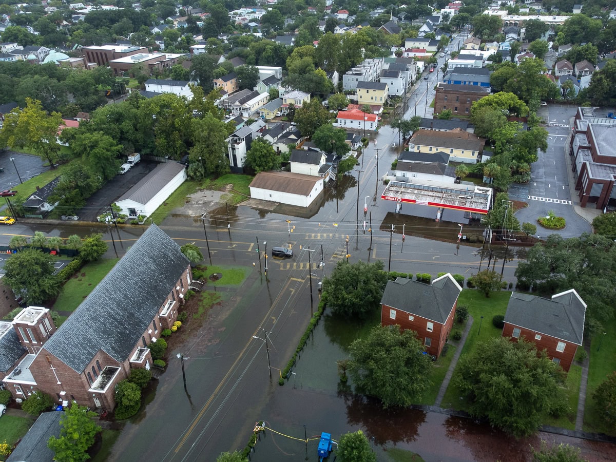
Charleston has always struggled with flooding due to its low-lying topography and coastal position. Over time, and in recent years, with increasing visibility, a cursed combination of development and rising sea levels converge to worsen the city’s flood risks.
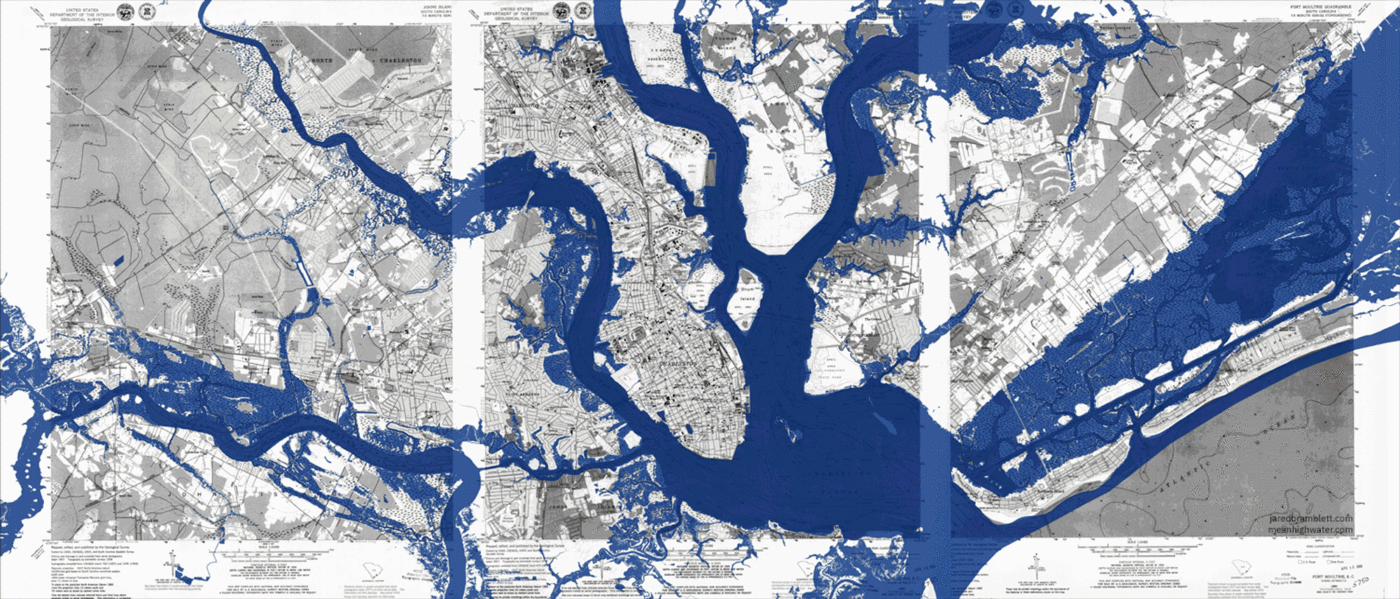
Bramblett tells me about something called the “Halsey Map,” a 1949 map that illustrates the city’s problematic longtime practice of expanding the peninsula by artificially filling creeks and marshes.2 The map shows how many of the areas which flood the worst are on man-made land–the peninsula today is twice the size it was when Charleston was founded at Oyster Point in 16803. For example, the area around the Medical University of South Carolina, featured in many of Bramblett’s photos, is built entirely on this artificial fill.
“I refer to these areas as ‘ghost creeks,’” Bramblett says. Alongside a series of photos of flooding on Halsey Street, built upon the artificially filled area that used to be Halsey Creek, Bramblett writes, “Mother Nature Doesn’t Forget.”
One of the motivations behind Mean High Water, Bramblett says, is “to make a record of this moment in time, and show how it’s going to look different in the future because of choices we do or don’t make about infrastructure and building today.” As most Charlestonians will tell it, activists and nonprofit organizations tend to face resistance more than support from the city commonly. Take, for example, the grassroots coalition of concerned citizens, Friends of Gadsden Creek (FOGC), who has, for years, opposed efforts to continue to fill the Gadsden Creek and build luxury apartments on the historically Black Westside.4 Despite widespread local support for FOGC, on Oct. 9, 2024, the South Carolina Supreme Court ruled that the WestEdge Foundation can destroy Gadsden Creek for commercial development. Meanwhile, the city has poured millions of dollars into projects such as the Low Battery Seawall Repair, aimed to protect the oldest, most expensive homes on the Charleston Battery.5
Beyond constant debates, proposals, conflicts, and projects, there’s another issue at hand here in South Carolina, which is calling out the cause of these rising tides for what it is: climate change.
Some folks still won’t call it that, Bramblett says, despite the undeniability of the worsening effects–from a rainfall so historic in 2015 it’s been dubbed the “thousand-year flood,” to the fact that the term “King Tide” has entered the local lexicon to describe events where streets will flood dramatically without a big storm.
“I’ve probably taken more photos of King Tide flooding than of stormwater flooding,” Bramblett explains. “In part, to show the impact that rising sea levels have on this city when it’s not an extreme event, where it’s not something we can predict and prepare for.”
While he was at a conference in Georgetown, SC, Bramblett shared, the mayor of Beaufort explained how, when he’d go stand on the docks of his township, citizens would point out how much higher the water had gotten, even if they didn’t necessarily want to name it climate change. “He shared this to say, we have to show and talk about the real impacts of this–not the theoretical–for people to understand.” And that’s exactly the aim of the Mean High Water Project.
Bramblett offers various entry points to his work, from sharing images and accessible information on his website and social media to giving lectures and podcast appearances. In 2017, the (now-defunct) nonprofit Enough Pie presented an exhibition featuring Bramblett’s work, Awakening V: King Tide.
“I’m trying to capture photos that invite people to look a little closer, rather than just capturing the devastation or the shock of it all,” Bramblett says. “That’s where I think art plays the most powerful role when it’s something that you can sit with and draw your own conclusions from. I hope that by capturing these moments, I can invite people to ponder and think about our path forward.”

[1] City of Charleston. “Charleston Water Plan (Comprehensive Integrated Water Plan).” Charleston, SC – Official Website. Last modified February 21, 2025. https://www.charleston-sc.gov/2818/Charleston-Water-Plan-Comprehensive-Inte.
[2] South Carolina Historical Society. “Alfred O. Halsey, Historic Charleston on a Map: Showing Original High Tide Water Lines, Fortifications, Boroughs, Great Fires, Historic Information, etc.” South Carolina Historical Society Shop. Accessed February 21, 2025. https://shop.schistory.org/products/unframed-halsey-map?variant=40115874234426.
[3] City of Charleston. “History.” Charleston, SC – Official Website. Last modified February 21, 2025. https://www.charleston-sc.gov/2010/History.
[4] Friends of Gadsden Creek. “Home.” Friends of Gadsden Creek. Accessed February 21, 2025. https://friendsofgadsdencreek.com/.
[5] City of Charleston. “Low Battery Seawall Repair.” Charleston, SC – Official Website. Last modified February 21, 2025. https://www.charleston-sc.gov/1193/Low-Battery-Seawall-Repair.
View Jared Bramblett’s Mean High Water project online at meanhighwater.com.